|
|
|
NatureServe held a formal five-day training course at the Hotel Portal del Sol in Asuncion, Paraguay on March 9-13 of 2009. This training activity provided innovative concepts and tools to measure the effectiveness of the implementation of an existent environmental policy as a key factor for biodiversity conservation, particularly for migratory bird species. This training activity was develop for 17 �mid-level� decision-makers as focal points and delegates from Argentina, Brazil, Chile, Colombia, Ecuador, Paraguay, Peru, and Venezuela supported WHMSI�s priority topic area of Area Social and Economic Issues.
The training activity accomplished the following objectives.
Objective 1: Train decision makers to use practical statistical tools to evaluate options for successfully implementation of environmental policy. The application of the methodology and analysis in this course was very useful for medium-level decision makers and policy advisors in the biodiversity conservation of migratory species of a specific country.
Objective 2: Increase human resource capacity for effective wildlife conservation and management in Latin America by increasing conceptual understanding of the linkages between environmental policy, biodiversity conservation and information management. Using a practical case study from Paraguay, this training activity demonstrated the complexity in the use of data and information management, and the integration of biodiversity data with social and economic information.
Objective 3: Contribute to the WHMSI initiative by providing a theoretical concept of the linkages between environmental policy, biodiversity conservation, and information management. The purpose of teaching statistics was to give participants experience in performing similar operations multiple times on three selected environmental policy from our case study. Based on the experience in the application of correlation coefficients in other countries, the course educated participants to simply apply statistics in a geographic context and make a final interpretation of the results.
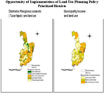
2. Methodology The core concept of this methodology was the implementation of efficient environmental policy to achieve sustainable development and biodiversity conservation of migratory species at municipality level, which vary according to the legal, social, economical, and environmental factors. We used a case study in the Guarani aquifer region in 108 municipalities within seven Departments of the eastern region of Paraguay: Amambay, Canindey�, Caaguaz�, Guair�, Caazap�, Alto Paran�, and Itap�a (Map 1).
This course assessed the opportunities of implementing three main environmental policies (Secretaria del Ambiente 2004)
- Land Use Planning policy in Municipalities and Departments. - Environmental quality control related to the preservation, conservation, use and management of natural resources available and its uses in Municipal territory for the production of goods and services in the Department. - Environmental impact assessment for environmental management decentralization that allows preservation, conservation, use and management of natural resources in a sustainable way.
In this course we used a bivariate analysis and selected two categories of ordinal variables: independent and dependent. The basic independent variables were the land cover, population, municipality income, environmental laws, and migratory birds species. Each independent variable had dependent variables, as shown in Table 1. Relationships were drawn by each independent variable with all dependents. Gamma was the statistical correlation coefficient used for measuring the association between the ordinal variables.
Finally, a spatial representation or mapping using a GIS application was used to graph the final outcomes or products. The course provided all technical assistance and computers to run Excel, Power Point and Arc View 3.3. Software. The 50 hour course consisted of five, 10-hour business days (Monday through Friday). An example is showed.
3. Conclusions and recommendations
The analysis of the implementation of environmental policy was very satisfactory, as evidenced in participants feedback. Students were motivated, participatory, and committed to WHMSI training opportunities. NatureServe greatly improved the course content, teaching method, organization, and logistics for this training course.
Participants were extremely motivated in the application of innovative statistical tools and GIS techniques for mapping environmental policy. As a result, the students went far beyond the planned training tasks.
Participants found the Aquifer Guarani topics interesting and challenging, particularly the practical exercises to identify the correlation between social, legal and economic values and biodiversity distribution. The evaluation of the course by participants was graded an average of 4 over 5 points. This is an extremely positive result. it demonstrates the potential to replicate to similar audience of decision makers in the future. The application of a Geographic Information Systems (GIS), the Arc View 3.3 in the spatial analysis of the statistical results, brought participants a comprehensive conceptualization of environmental policy analysis. These maps were very useful during the final presentations of each group and promoted discussion about similar policy analysis in other countries.
The participants expressed their commitment to participate and support training courses in conservation planning, species distribution modeling, climate change and environmental policy analysis by country in the future. From my point of view, this particular group of participants can be the seed to establish a technical teamwork specialized in biodiversity information management and environmental policy tools for decision makers within the region.
We would like to acknowledge the Conservation Data Center of Paraguay, as part of the environmental authority of the Secretaria del Ambiente (SEAM) and member of the Nature Serve�s ARRIBA network of Latin America and the Caribbean, for its support in the logistics and permission to use its statistical and spatial information, which was utilized during the training course. We like to acknowledge, as well, the GIS Laboratory (CAE) of the Institute of Ecology of the Universidad Mayor de San Andres (UMSA), Bolivia for its technical support in the Migratory Species Distribution Modeling, also has been used in the course. Special acknowledgement to the technical staff from NatureServe and OAS-Washington DC, for their collaboration and support.
Instructor Juan Pablo Arce, MSc. Director of Latin America and the Caribbean, NatureServe www.natureserve.org
|
||||||||||||||||||||||||||||||||||||||||||||
|
This page was last updated on Wednesday December 16, 2009. |

 1.
Objectives
1.
Objectives